

Dique Los Alazanes
The mountain reservoir at the foot of Uritorco. Capilla's most popular trekking destination: crystal-clear water surrounded by mountain ranges.
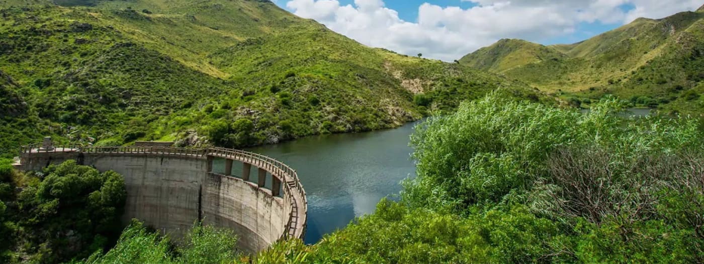
Dique Los Alazanes is a small mountain reservoir located at about 1400 meters above sea level, nestled between the Uritorco and Las Gemelas hills, in the heart of the Capilla del Monte mountain range. It is considered the highest dam in the province of Córdoba and one of the highest in Argentina. Its crystal-clear waters, surrounded by rock and mountain vegetation, are fed by the Los Alazanes stream and supply drinking water to the town. There is no vehicular access: the only way to get there is on foot, by horse, or by mule, which has made it one of the most sought-after treks in the area. The route crosses the river several times and goes through mountain landscapes until reaching the water mirror, an ideal place to rest, take photos, and enjoy sport fishing.
What makes this place unique
- The tallest dam in the province of Córdoba, at about 1400 meters above sea level
- Crystal-clear mountain waters surrounded by the Uritorco and Las Gemelas hills
- The pedestrian bridge over the dam crest, about 71 meters long
- The numerous river crossings along the trail
- Sport trout fishing and an ideal setting for nature photography
A bit of history
The dam was designed and built by the General Directorate of Hydraulics of the province of Córdoba to ensure the supply of drinking water for Capilla del Monte. The works took place in the mid-20th century (sources place its construction between the late 1930s and 1949, with inauguration around 1949), under very difficult conditions: since the site had no vehicle access, a large part of the materials were transported by mule through the mountains. The concrete arch dam is about 25 meters high, and its crest, which serves as a pedestrian bridge, is about 71 meters long. It is mentioned as one of the first arch dams in South America. It is still in operation today, managed by the provincial water resources authorities.
URI's tips
Leave early to make the most of the day and return in daylight. Bring more water than you think you'll need, as the climb is demanding and the sun is strong. Check in at the park ranger's house upon arrival. As it is a mountain trail with no vehicle access and several river crossings, it is highly recommended to hire a certified local guide, especially if you don't know the area. Don't leave trash: everything you bring must come back with you.
What to bring
Comfortable trekking shoes, plenty of water, light food, sunscreen, hat, light jacket depending on the season, and a bag to take your trash back. It is advisable to go with a certified guide.
This is what Dique Los Alazanes looks like

How to get to Dique Los Alazanes
11 km from downtown Capilla del Monte. About 10 minutes by car from the center to the La Toma swimming area, where you leave your vehicle and start the hike.
From the center of Capilla del Monte, head towards the La Toma resort and campsite, at the foot of Cerro Uritorco (about 3 km from downtown). The trail starts at La Toma: walk upstream along the Calabalumba stream for a few minutes until you reach the Huertas Malas stream, where the climb begins (the first stretch, Cuesta del Toro, is the most demanding). The route continues deeper into the mountain and crosses the river several times (about 8 to 10 times) until reaching the dam. The total round trip distance is around 13 to 14 km. It is a moderate difficulty hike and it is recommended to do it with a certified guide, as well as registering at the park ranger station upon arrival.
Hiking routes around Dique Los Alazanes
Data from the Wikiloc community. Always check conditions and entry hours.
What everyone asks
Is a guide needed to go to Dique Los Alazanes?
It is not mandatory in all cases, but it is highly recommended to do the trek with a certified guide, as it is a mountain trail, of moderate difficulty, and with several river crossings.
How long does the trek take?
Allow between 3 and 4 hours for the ascent and about 2.30 to 3 hours for the descent. In total, it's a full day of approximately 6 to 8 hours, including the rest at the dam.
Can you get to the dam by car?
No. The dam has no vehicular access. You can reach La Toma resort by car, and from there you can only continue on foot, by horse, or by mule.

Who takes you
Operators licensed to run activities at Dique Los Alazanes.